ABOUT THE GREEN RIVER GAMELANDS
The 16 miles of trails in the Green River Game Lands are a joint project between the Environmental and Conservation Organization (ECO) and the NC Wildlife Resources Commission.
This project was made possible by many volunteers and organizations, including members of ECO, Carolina Mountain Club, Tryon Hiking Club, Henderson County Travel and Tourism, Polk County Travel and Tourism, and Luther E. Smith & Assoc., P.A., landscape architects. Thanks to Michael Arrowood and John and Gary Van Valen for mapping the trails and to John Van Valen and members of the Carolina Mountain Club for ongoing maintenance of the trails. After a severe ice and wind storm, CMC members spent 362 man-hours in January and February 2006 to clear the trails.
Description and Rules of the Green River Game Lands
The trails are located in the Green River Game Lands, a rugged tract of more than 10,000 acres along the Green River in Henderson and Polk Counties, NC. Owned by the state, the primary purpose of NC Game Lands is wildlife conservation and management — hunting, fishing, and trapping are allowed in Game Lands. The trails in this unique area are maintained to encourage and facilitate foot travel only.
Hikers should be cautious during hunting season, which is generally from mid-September to mid-May. Deer hunting season, for example, begins in mid-September and continues through mid-December. Seasons for other types of games run through mid-May. Hunters are most active on Fridays and Saturdays and at the beginning of individual game seasons.
- The trails in the Game Lands are unblazed. Markers indicate trails at their starting points. Markers show significant turns where needed.
- The terrain in the vast Green River Game Lands is rugged. Never hike alone. Always observe regular outdoor safety precautions.
- No camping is allowed.
- No ATVs or motorcycles are permitted.
- Horses are permitted May 15-Aug. 31 only.
DIRECTIONS TO TRAILHEADS
Access and Parking for Long Branch, Pulliam Creek, and Bishop Branch Trails
From I-26 near Hendersonville take exit 53 (Upward Rd.). Go east (away from Hendersonville) on Upward Rd. 1.8 mi. Turn right on Big Hungry Rd. (SR1802). Go 0.5 mi. and then take a left turn, continuing on Big Hungry Rd. Go 0.3 mi. and take a right turn, continuing on Big Hungry Rd. Go 1.7 mi. to the bridge crossing Big Hungry River (good fishing spot!),
Parking for Pulliam Creek Trail: From the bridge, drive 2 mi. to a small pull-off area along the right side of the road at a Wild Trout Waters sign.
Parking for Bishop Branch Trail: From the bridge, drive 2.4 mi. to a large paved area on the right.
Parking for Long Ridge Trail: From the bridge, drive 2.9 mi. to a small parking area off the road on the right. More parking space is 0.1 mi. further, at the end of the road. (The ford there across Bishop Branch is a private road — do not block that road!)
Access and Parking for Green River Cove Trail
From I-26 near Hendersonville take exit 59. Go east, away from Saluda, and very shortly turn left onto Green River Cove Rd. Drive 3.9 mi. (many hairpins turns), cross the bridge, and park on the right. The trailhead is across the road. Extra parking is just before the bridge on the left.
TRAIL DESCRIPTIONS
Green River Cove Trail – 3.5 mi.
Starting point: near the bridge on Green River Cove Rd., 1.1 mi. downriver from Fishtop River Access.
Moderate, 7 miles round-trip, approx. 400 ft. elevation change.
This hike begins with a gradual grade up a steep bank. The trail offers continuous views of Green River, both its calm, easy-flowing areas and its intense rapids. The entire length of the trail follows the north bank of the river (good fishing spots!). There are several stream crossings. The trail intersects Bluff Trail 250 yds. on the right, and Pulliam Creek Trail on the right approx. 3/4 mi. before ending at a boulder-strewn section of the river just below The Narrows. (The Narrows is a dangerous, narrow section of Green River with powerful rapids.)
Starting point: this is a connector from the Green River Cove Trail to Turkey Gut Trail.
Strenuous, 1 mile, an elevation change of 700 feet
This is a challenging trial. Approx. 250 yards up Green River Cove Trail, Bluff Trail intersects on the right. Bluff Trail climbs a steep boulder-strewn slope over a series of stairs and switchbacks. At the top of the ridge turn sharply to the left (west) and continue in that direction to the intersection with Turkey Gut Trail. Climbing continuously except for very short stretches, Bluff Trail follows an old roadbed at times, at others is a faint footpath. The upper stretch may be overgrown in summer.
Starting point: this is a connector from Green River Cove Trail to Long Ridge Trail
Strenuous, approx. 1-3/4 mi., 1,200 ft. elevation change.
Another challenger! Go 2-3/4 mi. on Green River Cove Trail to Pulliam Creek Trail on the right. Go on Pulliam Creek Trail approx. 1/4 mi. to Bear Branch Trail on the right. This takes you up the spine of the ridge. After the initial climb, the trail veers to the right and parallels Bear Branch for a while and then continues climbing via switchbacks. After a hairpin turn to the right (almost a mile up), the trail widens, passes a forest road on the left and then past Bishop Branch Trail on the left before ending at Long Ridge Trail.
Starting point: Big Hungry Rd., 2.9 mi. beyond the bridge at Big Hungry River on the right.
Easy trail, 4 miles round-trip, an elevation change of approx. 200 ft.
This pleasant walk begins at the parking area. Walk around the left gate and along the roadbed, which crosses Bishop Branch very near the gate.
A few hundred yards up Long Ridge Trail, a forest road to the left leads to Stairstep Falls Trail A side loop from the road forks to the left and rejoins Long Ridge Trail in a short distance. Long Ridge Trail continues straight ahead along an old clear-cut.
Long Ridge Trail continues straight ahead along the ridge and ends at a knob, which is a wildlife clearing. Tryon Peak can be seen to the east and Green River Gorge to the south.
Return to the trailhead by the same route.
Starting point: accessed from Long Ridge Trail
Moderate trail, 3 mi. round-trip from trailhead, elevation change of about 500 ft.
This trail branches to the left off Long Ridge Trail approx. 3/4 mi. up Long Ridge Trail
Follow the well-defined roadbed about 1/4 mi. to where a short road on the right leads to a wildlife clearing. After this road, the roadbed narrows to a trail.
Approx. 1/4 mi. farther, you will see Stairstep Creek on the right. Stairstep Falls Trail veers to the right across the creek.
Turkey Gut Trail continues along the left bank of the creek following a downhill slope with nice views of the creek and small waterfalls.
In approx. 1/4 mi. a rock outcropping rises above the trail on the left. In approx.1/2 mi. the trail ends above Green River Gorge. In winter there are views of the gorge and Pace Cliffs, an outcropping east of the trail end.
Stairstep Falls Trail – 1.5 mi.
Starting point: this is a connector from Turkey Gut Trail to Long Ridge Trail.
Moderate, approx. 1-1/2 mi., 300 ft. elevation change.
Approx. 1/2 mi. on Turkey Gut Trail take a sharp right to cross Stairstep Creek (creek goes underground at the crossing.) Keep left as the trail descends gradually to a small creek crossing (1/2 mi. from the trailhead), then narrows and climbs rapidly to a ridgeline. A faint path follows the ridge for 3/4 mi. (Caution: the steep and dangerous Loobie Cliffs are below the trail to the left.) After the trail leaves the ridge, you’ll cross a wildlife meadow and follow a roadbed 200 yd. to Long Ridge Trail
Pulliam Creek Trail – 3.25 mi.
Starting point: Big Hungry Rd., 1 mi. beyond the bridge over Big Hungry River on the right.
Moderate, 6-1/2 mi. round-trip, 900 ft. elevation change.
This trail offers some of the most exciting terrain and plant variety in the area, passing through mature forests and contouring along deep gorges.
The trail begins at the roadside with a footbridge across Pulliam Creek. The trail parallels the creek, crosses it again at 1-1/2 mi., then turns steeply uphill. After 300 yds. it intersects an old roadbed and continues to the right. (Note: the left fork is not maintained and merely loops to Pulliam Creek.)
Approx. 2 mi. from the trailhead, a narrow downhill path on the right leads to The Narrows of the Green River. The Narrows are extremely dangerous, and the path is steep, hazardous, and absolutely not recommended! About 100 feet beyond that is a faint path on the left which leads to Bear Branch Trail Pulliam Creek Trail continues straight ahead, descending gently 1-1/3 mi. to intersect with Green River Cove Trail
At Green River Cove Trail, go left to access the trailhead parking area … or go right 3/4 mi. to the Green River below The Narrows.
Starting point: this is a connector from Pulliam Creek Trail to Bishop Branch Trail.
Easy, just under 1/2 mi., no elevation change.
Approx. 1/2 mi. on Pulliam Creek Trail turn left at an obtuse angle. Descend to Pulliam Creek and cross the creek on rocks just below the confluence with Bishop Branch. Later the trail crosses Bishop Branch. The trail ends at a wildlife clearing and Bishop Branch Trail.
Bishop Branch Trail – 1.25 mi.
Starting point: Big Hungry Road, 2.4 mi. beyond the bridge over Big Hungry River on the right.
Easy, 2.5 miles round-trip, descend 200 ft. and ascend 200 ft.
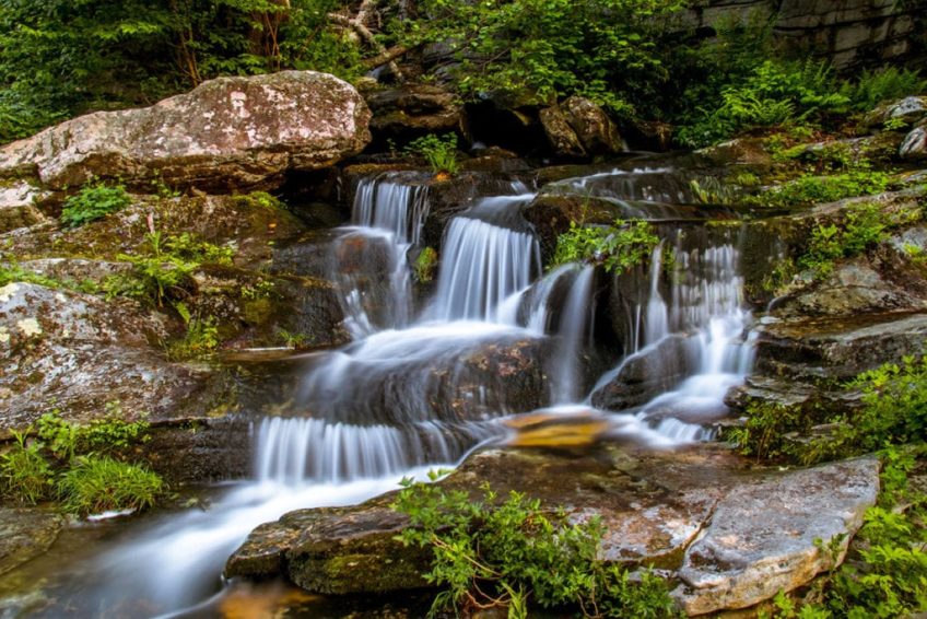
From the parking area walk approx. 25 yds. down Big Hungry Rd. to a metal gate on the right at the Bishop Branch trailhead. This trail is an old roadbed that descends gradually to Bishop Branch. (At 3/8 mi. a roadbed to the left leads to a series of wildlife clearings and the Long Ridge trailhead.) Bishop Branch Trail continues straight ahead and passes a small but pretty waterfall on Bishop Branch. When the roadbed opens up into a wildlife clearing, go straight across the meadow and look for foot logs across the branch. Within 100 yards the faint path crosses another small branch and shortly intersects another roadbed. Follow the roadbed uphill going parallel to the branch to the intersection with Bear Branch Trail at an old clear-cut. You may backtrack or return to Big Hungry Rd. via Bear Branch Trail.